St. Moritz to Lake Staz to Celerina (or Pontresina) 
Distance: 4.0 - 8.4 miles
near St Moritz in Eastern Switzerland
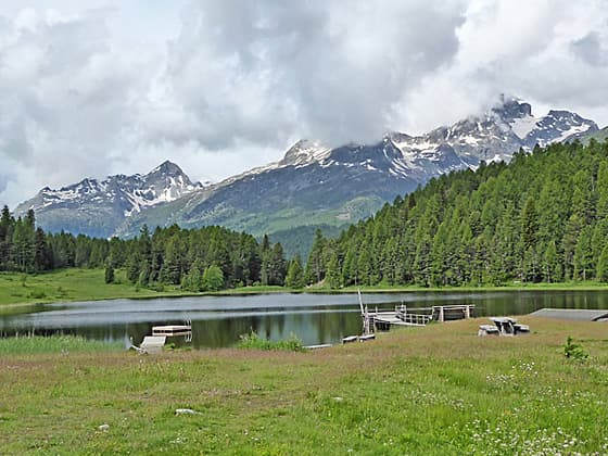
Beautiful view of Lej da Staz and the peaks to the northwest
The short, easy hike to lovely Lake Staz (Stazersee / Lej da Staz) offers mountain views, a restaurant, picnic spots, a playground, and swimming in warmer months. The path is suitable for everyone with connecting trails allowing hikers to easily visit Celerina or Pontresina.
- Distance: 4.0 - 8.4 miles (RT)
- Elevation: 5,810-ft. at Trailhead
Maximum elevation - 6,040-ft. - Elevation Gain: 230-ft.
- Difficulty: easy
- Basecamp: St Moritz
- Region: Eastern Switzerland
Trail Description - St. Moritz to Lake Staz to Celerina (or Pontresina)
Sometimes the weather does not cooperate, cloaking the high country in clouds. On other days you may feel like taking it easy and strolling to a pretty spot where you can have lunch or a picnic in a relaxing atmosphere. Lake Staz (Lej da Staz in Romansch) is a great choice in both circumstances.
Lake Staz (Lej da Staz) (5,935-ft./1,809 metres) lies nestled in the Stazerwald forest between St. Moritz and Pontresina. Lovely views of the surrounding mountains, a restaurant, picnic areas and a playground, along with swimming in the warmer months, draw locals and visitors alike to this pretty destination. The walk is suitable for just about everyone and can be done at any time of the year. The paved and hard packed trails in the area accommodate strollers and wheelchairs as far as Lake Staz.
The path to Lake Staz can easily be combined with a walk around Lake St. Moritz. Extend the hike by using the trail system around the late to walk to and explore Celerina or Pontresina. Easy transportation links ensure a quick trip back to St. Moritz.
To Lake Staz
Start the hike to Lej Staz (Lej da Staz in Roansch) at the Catholic Church (Kath. Kirche) in St. Moritz Bad or at the St. Moritz Bahnhof (train station) in St. Moritz Dorf. (See directions to the trailhead below.)
Note: There are two parts to St. Moritz, the upper village, St. Moritz Dorf (Dorf mean village), and the lower section along the southwest end of Lake St. Moritz, St. Moritz Bad. The Bad area is the source of the mineral waters feeding the Spas (health centers), where tourism originated in the area.
From the Catholic Church in St. Moritz Bad: From the Catholic Church (Kirche St. Karl Borromäus) bus stop, walk east on the sidewalk along the road (Via Sela) to a path that quickly leads to the southwest corner of Lake St. Moritz (St. Moritzsee). Here views open north across the lake to St. Moritz Dorf, set amid the lower slopes of Piz Nair. Turn right (east/northeast) and follow the broad path beside the lakeshore as it passes a few apartment buildings in St. Moritz Bad and then travels along a wood hillside. Piz Padella rises to the north.
After 1.0 mile reach the east end the lake and take the trail branching right toward Lej da Staz. There is a large wood carving of a squirrel along with trail signs mark the turn.
Follow the trail through meadows with nice views (west/northwest) of St. Moritz and the lake. Soon we turn left in the direction of signs for Lej da Staz and St. Moritz Dorf. This section of the trail passes the west side of the Hotel Landgasthof Meierei St. Moritz. reaching an intersection at 1.3 miles. The trail to the left head back to St. Moritz Dorf and the lake. We turn right on a good gravel path toward Lej da Staz, Celerina and Pontresina.
If walking from the St. Moritz Bahnhof (train station): From the train station, descend the stairs in the station and follow the underground passage way to the north side of the lake. Signs will point to the Seerundweg (Lake Circuit) and lead you to the north side of Via Grevas, a busy street. Cross to the south side of the street at the pedestrian crossing and then turn left. A short walk leads to the bridge crossing the outlet stream for Lake St. Moritz (St. Moritzsee). Cross the bridge and then turn right. You are now on the trail traversing the east side of the lake. Follow the trail for 0.9 miles to a good gravel path branching left with signs pointing toward Lake Staz.
Head east on the trail. Soon you will reach a junction across from the Hotel Landgasthof Meierei St. Moritz at 1.1 miles. Here signs point to the continuation of the path toward Lej da Staz, Celerina and Pontresina. This trail is slightly shorter than the path from Bad, so subtract 0.2 miles from the mileage for the rest of the hike if starting at the train station.

Both trails now follow the same directions toward Lej da Staz. After passing the hotel and a dairy barn, the trail continues east, reaching Lake Staz at 1.6 miles. Here pretty views extend across the lake to the peaks rising above the east side of Val Bernina, home to Pontresina. Information signs near the lake explain that all the moor areas around the lake are protected and part of the Stazerwald (Staz Forest).
Follow the path along the north side of the lake with fine views of the surrounding peaks. Reach a “Y” intersection at the north end of the lake at 1.9 miles. Here you have three options: have an easy day around the lake and then return to St. Moritz, walk to Pontresina or walk to Celerina.
St. Moritz to Lake Staz (Lej da Staz) (Round Trip or Loop)
- Distance: 4.2 – 4.4 miles (RT or Loop)
- Starting Elevation: 5,810-ft.
- Highest Point: 6,050-ft.
- Elevation Gain: 280-ft.
 To have an easy day and return to St. Moritz, take the trail branching right which leads to the Lej Staz restaurant and nearby picnic areas. After enjoying a break and possible some refreshments, either turn around and return the way you came for a 4.0-mile round trip or continue along the trail as it circles the south side of the lake before heading back to St. Moritz.
The path circling the lake features beautiful views across Lake Staz to the peaks rising above the north side of the Upper Engadine. Beyond the lake the path travels through meadows and forest, offering two return routes. The first is to follow the signs back to St. Moritz Bad (4.2 miles). This will ultimately lead you to a road that passes by the Youth Hostel and housing before reaching and intersection with Via Sela. Here several buses stop on their routes to St. Moritz Dorf. You can also turn right on Via Sela and head back to the lakeshore near the Catholic Church.
The second option is to watch for signs pointing to Meierei. Turn right when you see the sign and then follow the Meierei signs back to the Hotel Landgasthof Meierei St. Moritz. At this point, retrace your steps back to Lake St Moritz and then follow the signs to the St. Moritz Dorf train station (approx. 4.4 miles RT).
St. Moritz to Lake Staz to Pontresina
- Distance from St. Moritz Bad to Pontresina: 3.8-4.2 miles (one-way)
- Starting Elevation: 5,810-ft.
- Highest Point: 6,055-ft.
- Elevation Gain: 300-ft.
If you wish to explore Pontresina, at the train station turn right, walking along the road which turns into Via da la Staziun. The road crosses a river and then reaches a “Y” intersection. Bear right and ascend along road as it crosses the highway and then the River Flax. Continue up the road a short distance and cross Via Da Mulin. Just beyond turn right on a walkway (La Senda) that climbs to Via Maistra, the main street in Pontresina at 4.2 miles.
St. Moritz to Lake Staz to Celerina
- Distance from St. Moritz to Lake Staz to Celerina: 4.2 miles (one-way)
- Starting Elevation: 5,810-ft.
- Highest Point: 6,050-ft.
- Elevation at Celerina: 5620
- Elevation Gain: 290-ft.
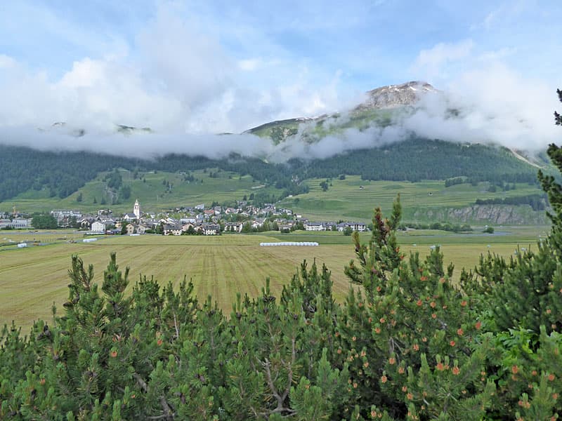
 Note: As you walk to Lake Staz you will see signs for Celerina and Celerina Staz, both with train icons. The Celerina station, on the train line running to the lower Engadine, is located in the town of Celerina, while the Celerina Staz station, on the Val Bernina line, is on the southern outskirts of town, across the highway from Celerina. Trains from both stations head to the St. Moritz train station. For this hike, we will be heading toward the town of Celerina and not Celerina Staz.
To walk to Celerina: From the “Y” intersection on the north side of Lej da Staz (1.9 mile from St. Moritz Bad), bear left on the trail toward Celerina (Schlarigna in Romansch), which curves to the north. The path initially travels through meadows and then enters the forest. The meadows and openings in the forest offer nice views of the peak towering above the east side of the Bernina Valley, home to Pontresina. Note that various trails branch off to the right and the left. If you look at the map you will see there is a good network of trails through the forest, allowing for a variety of loops that return to the lake, St. Moritz, Pontresina or other destinations.
At 2.2 miles reach a “Y” junction were where the trail to the right and left both lead to Celerina/Schlarigna. Either trail works. The path on the right, the continuation of the wide gravel track, is the more frequented trail. On the way out we took the trail to the right and used the other trail on the way back. Whichever trail you choose, continue walking in the direction of Celerina at all intersections.
The path now descends on easy grades through forest toward Celerina. As you near Celerina you will start seeing signs for both Celerina and Celerina Staz. Continue toward Celerina. The broad path will soon curve to the left at 3.1 miles. A short distance beyond, take the paved track to the right toward Celerina. The path soon crosses a train track and then a bridge over a highway.

As you cross the bridge, note Church San Gian, with the ruined tower, in the field to the north. A detour to visit the church is recommended. Past the bridge continue up the road to where it ends at Via San Gian (a street). To visit the church, turn right on Via San Gian and walk a short distance along the road to the street leading to church. Here we turn left, walking along the road toward the church and then up the steps to the church, set upon a low hilltop.
Church San Gian (built in 1478) was hit by a lightning strike in 1682, which damaged the church tower. The tower was never restored. The ruined tower is now a dominate feature of this landmark. If you are lucky, the church will be open and you can see the interior. Otherwise, enjoy the views of the surrounding area from the walkways around the church and the small hilltop. (Note: There is bathrooms to the left of the cemetery, located behind the church.)
When you are done viewing Church San Gian, return to Via San Gian (the street) and take a right, walking toward the town of Celerina. The road soon enters town, crossing a bridge over the River Inn.
To reach the train station, walk straight ahead until you see train tracks and then turn left to find the station with trains back to St. Moritz at 4.2 miles. Walking around the small town is enjoyable, with old buildings set along narrow cobblestone lanes. Coffee shops and restaurants are available for anyone wishing to take a break.
Return to Lake Staz and St. Moritz on Foot
- Distance from St. Moritz to Lake Staz to Celerina: 8.4 miles (round trip)
- Starting Elevation: 5,810-ft.
- Highest Point: 6,050-ft.
- Elevation at Celerina: 5620-ft.
- Elevation Gain: 600-ft.
Elevation Profile
Driving Directions
Note: There are two parts to St. Moritz, the upper village, St. Moritz Dorf (Dorf mean village), and the lower part along the southwest end of Lake St. Moritz, St. Moritz Bad. The Bad section is the source of the mineral waters feeding the Spas (health centers), where tourism originated in the area.
From St. Moritz Bahnhof (Train Station) in Dorf: At the St. Moritz Train Station descend the stairs and follow the underground passage way to the north side of Lake St. Moritz. Signs will point to the Seerundweg (Lake Circuit). Then follow the trail directions (above) to Lake Staz.
From St. Moritz Bad: From other locations in St. Moritz, take the #6 or #9 bus to the St. Moritz Bad Catholic Church (St. Moritz Bad, Kath. Kirche) stop. Here paths lead to southwestern shore of Lake St. Moritz. Then follow the trail directions (above) to Lake Staz.
For more information visit the Engadine Bus Routes website, go to SBB website or download the SBB app to find the current bus/train schedule for the bus/train stop nearest to your accommodations.
Trail Resources
- Trail Photo Gallery
- Trail Maps
- Basecamp(s) Information: St Moritz
- Region Information: Eastern Switzerland
- Other Hiking Regions in: Switzerland