
Mount dell Oro and the step up along the valley floor.
The hike to Val Fedoz, a secluded hanging valley, travels through lovely meadow with wonderful views of the cirque at the head of the valley and the surrounding peaks.
- Distance: 7.1 - 10.0 miles (One Way)
- Elevation: 5,954-ft. at Trailhead
Maximum elevation - 6,932-ft. - Elevation Gain: 978-ft.
- Difficulty: moderate
- Basecamp: St Moritz
- Region: Eastern Switzerland
Trail Description - Val Fedoz
This hike explores the wild and scenic Val Fedoz (Fedoz Valley), a secluded hanging valley along the south side of Silsersee (Lake Sils). Here you will immerse yourself in nature and solitude, hiking through lush meadows sprinkled with wildflowers beneath the high peaks rimming the valley. A charming stream, the Aua da Fedoz, meanders down the valley floor. Great views of the Fedoz glacier, cascading down the beautiful cirque at the head of the valley, entices hikers to explore further.
Beginning in Sils/Segl Maria, the trail winds through forest before climbing the east side of Val Fedoz to Alp Motta Salacine, near the valley's head. It then crosses a bridge over the Aua da Fedoz and descends along the west side, eventually joining the path along the Silsersee to Maloja. The hike can easily be reversed by starting in Maloja. Shortened the hike by 2.9 miles (1.5 hours) using mid-valley bridges. Alternatively do the hike as an out-and-back from either location.
To Val Fedoz
Distances to Val Fedoz
- Sils Maria/Segl to Maloja via Val Fedoz: – 10 miles (point-to-point)
- Shortened hike using Mid-valley Bridges: 7.1 miles (point-to-point)
- Sils Maria/Segl to Val Fedoz: 9.2 miles (RT)
- Maloja to Val Fedoz: 10.8 miles (RT)
Note: Piz in Romansh, a language spoken by some in the Swiss Engadine, means peak and lej, leg and lai mean lake. (Piz Lagrev is Lagrev Peak and Lej Segl is Lake Segl, or in German: Silsersee.)
This hike starts by taking the bus to Sils/Segl Maria, Posta stop. (See the Directions to the Trailhead for more information.) From the bus stop walk south/southwest along Via da Marias (the main street in Sils) in the direction of the Geschenkladen Butia, a small shop. Follow Via de Marias for 700-ft. (220-meters) to an intersection where you will see the Chesa Cumunela (the City Hall) on the southwest corner and the Hotel Privata.
Ascend the paved road marked with a black sign reading “Vai da Fex,” located to the left of Hotel Privata, and head toward the Arenas Hotel, a tall white building. Do not follow the paved sidewalk to the left with yellow trail signs for Val Fex.
After climbing a switchback, the road curves behind the Hotel Waldhaus Sils and passes a few buildings on the right. Past the last building, near tennis courts on the left, turn right at the yellow hiking signs pointing to Val Fedoz, Val Fex, Isola, Maloja and Muott Ota. This turn is 0.3 miles from the Chesa Cumunela. Immediately after, at a “Y” intersection, stay left on the trail signed for Val Fedoz.
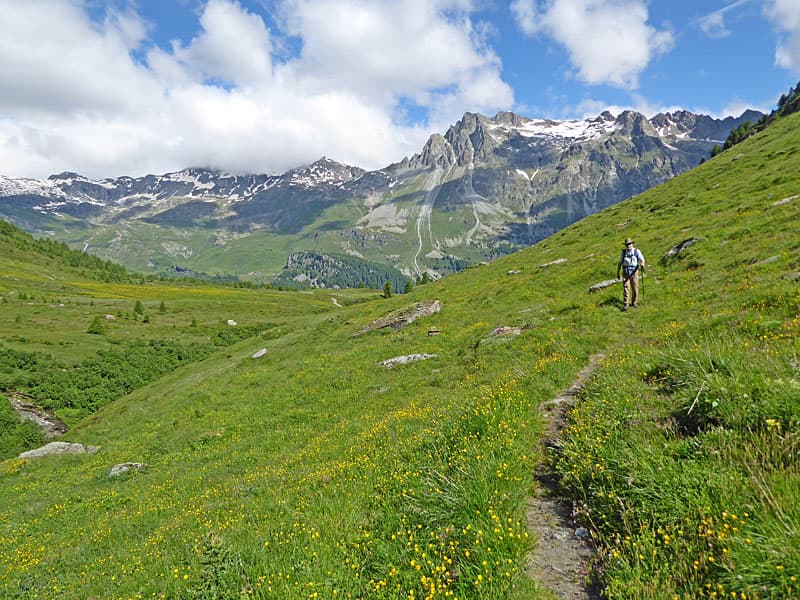
The trail heads south/southwest, ascending on easy to moderate grades through forest and crossing the foot of Val Fex, the valley paralleling Val Fedoz to the east. Openings offer glimpses of the high peaks rising to the northwest of the Silsersee. At all intersections, follow the signs for Val Fedoz.
After 1.0 mile, reach a junction where the trail turns left and climbs through forest past a few homes in Val Fex. Intermittent meadows offer views of the peaks to the northwest and Piz da la Margna, towering over Val Fedoz’s western flank.
The trail soon curves south around Muott Otta, the ridge separating Val Fex and Val Fedoz. As you climb a switchback, expansive views open to the peaks rimming the west side of Val Fedoz.
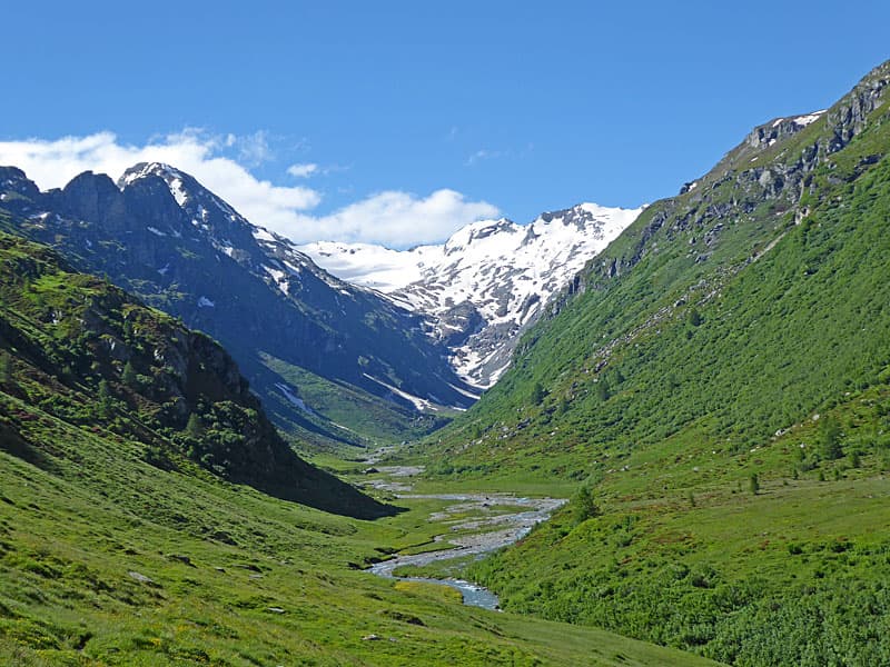
The trail now breaks from the trees and curves left into Val Fedoz, traveling through lovely meadows to the alp buildings at Petpreir (6,532-ft. / 1,991-m) at 2.0 miles. Here views extend to the ridge rising above the Silsersee, including Piz Lagrev and Piz Lunghin. Ahead is the beautiful, glacier-clad cirque at the head of Val Fedoz while Piz de la Margna dominates the view across the valley.
At a junction near Petpreir, follow the trail signed for Val Fedoz, which gently ascends southward through beautiful meadows on the valley's east side. (The trail to the right descends to and crosses the Aua da Fedoz, the valley’s stream, leading to Ca d’Starnum. This alternate route heads south along the west side of the valley and can be used to return to Sils/Segl Maria instead of Maloja at the end of the hike.)
The path occasionally fades but is easy to relocate. During peak wildflower season, the meadows are dotted with vibrant blooms, while hillsides are blanketed with thick clusters of pink alpenrose.
At 3.2 miles two bridges facilitate a crossing over the braided Aue da Fedoz to the west side of the valley. Here a decision can be made to cut the hike short. Crossing here reduces the hike by 2.9 miles for the 7.1-mile hike. I recommend continuing up valley for another 1.4 miles.
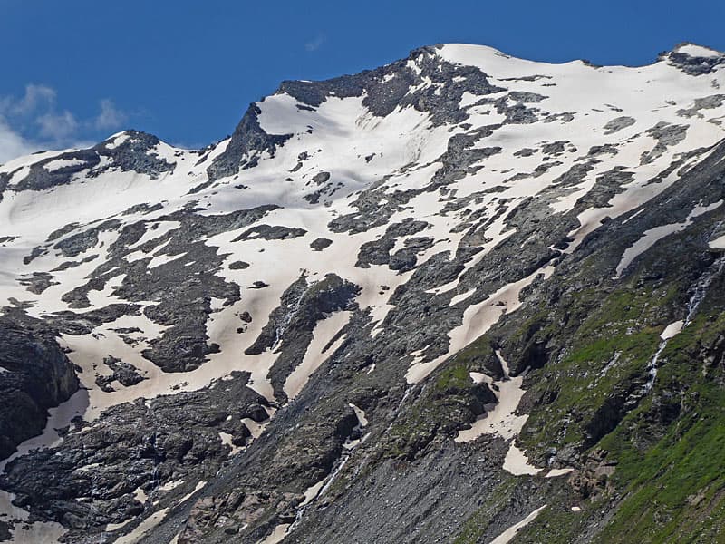
The valley now narrows. Across the valley waterfalls cascade down the steep slopes of Piz da la Margna while the snow is still melting. Ahead, vistas of the glacier-cirque continue to unfold with Mount dell'Oro dominating the view. Soon Piz del Muertto and Piz Fedoz join the scene.
At 4.3 miles, the valley constricts further, and the trail ascends a step up the valley on moderate to moderately steep grades. The climb navigates a rocky knoll, offering excellent views of Piz Lagrev rising to the north of Silsersee if you pause to look back.
At the top of the knoll, grand views reopen to the cirque. Below lies Alp Motta Salacine, which serves food and drinks during peak season. Descend slightly from the knoll to reach the alp buildings at Val Fedoz, (6,913-ft. / 2,107-meters) at 4.6 miles. Here signs point to the trail leading down the west side of the valley to Ca d’Starnam and Maloja.
From the alp, the trail curves through rocky meadows to a wood bridge crossing the Aua da Fedoz. Nice perches atop the rocks near the trail offer front row seats for a picnic with fabulous views of the beautiful cirque at the head of the valley.
After taking a break, follow the trail as it crosses the stream on a bridge. The path now heads down the valley’s west side on a trail hidden at times by dense foliage which makes it difficult to see where to place your feet. Thankfully this section is short and soon continues its decent through rocky meadows, crossing streams along the way.
The gentle descent features great views of Piz Lagrev to the north and a fresh perspective on the cirque. As you near mid-valley bridge, the view of the cirque expands to include Piz Fora and the Fedoz Glacier along with the ridge rimming the east side of the valley, dominated by Piz Guz, Piz Led and Piz Salatschina.
At 6.2 miles, pass the mid-valley crossing to the east side of the valley with signs for Petpreir and Segl Maria. A short distance beyond the trail starts an easy ascent on an ever-improving trail to Ca d’Starnum (6,594-ft. / 2,010-m), reached at 7.0 miles. Ahead are beautiful views of the peaks rimming the north side of the Silsersee.
At Ca d’ Starnum, signs point straight ahead toward Maloja. To return to Sils, follow the road a a brief distance, then turn right on the trail marked for Petpreir and Segl Maria. This path drops down the bridge, crosses the Aua de Fedoz, abd then climbs to Petpreir. From Petpreir, follow signs for Sils Maria/Segl to complete a 9.5-mile (RT) hike.

If heading to Maloja, continue straight ahead on the good gravel alp road, which descends on moderately-steep grades. At 7.3 miles the road reaches the foot of the valley, then curves left, leaving Val Fedoz. At 8.1 miles, it joins the broad path along the south side of the Silsersee. Along this stretch, enjoy wonderful views of the peaks rimming the north side of the Silsersee. (Watch for bikes on the descent.)
There are two options for returning to Maloja. You can turn left and follow the road back to Maloja or cross the road to the signed trail for hikers to Maloja. This trail offers better views and avoids bike traffic. The road is faster.
The trail rejoins the alp road shortly before the end of the lake. At the foot of the lake follow the road as it curves to the right along the lake shore. Midway along the lake signs point left to a track leading to Maloja and Maloja Post, where you can catch buses back to St. Moritz, or wherever you may be staying.
If reversing the hike and starting from Maloja Post: Follow the path leading to the Silsersee and then turn right, following the alp road and then a trail around the Silsersee toward Isola. Shortly before reach the large outwash plain of Isola, turn right on the alp road to Ca d' Starnam, which leads into Val Fedoz. Now reverse the directions above, ascending the west side of the valley, cross the bridge at Alp Motta Salacine and then descend the east side of the valley, either ending the hike in Sils or using the connecting trail between Petperir and Ca d' Starnam to return to Maloja. The out-and-back hike from Maloja is 11.4 miles (RT).
Elevation Profile

Driving Directions
From the St. Moritz Bahnhof (train station) to Sils/Segl Maria, Posta: At the St. Moritz Train Station board a #4 bus heading toward Chiavenna or Maloja Post or the #5 bus to Sils/Segl Maria Post and get off at the Sils/Segl Maria Post stop.
Get information from the local tourist office, visit the Engadine Bus Routes page, go to SBB website or download the SBB app to find the routes, schedules and stop nearest your accommodations. Note that some of the bus route may require you to change buses at Silvaplana, Kreisel Mitte (Stand A) to get to Sils/Segl Maria Post.
From the bus stop at Sils/Segl Maria Post, walk south (in the direction the bus is traveling) along the main street, Via de Marias, for 700-ft. (220-meters) to an intersection. (The Chesa Cumunela (the City Hall) is located across the street.) In front of you is the Hotel Privata. Ascend the paved road marked with a black sign reading “Vai da Fex,” located to the left of Hotel Privata, and head toward the Arenas Hotel, a tall white building. (Do not follow the paved sidewalk to the left with yellow trail signs for Val Fex.) This will lead to the trail to Val Fedoz. See the hiking description for more information.
From Maloja to St. Moritz: At the Maloja Post, board a #4 Postbus to St. Moritz Bahnhof (train station). The ride takes about 41 minutes. Note the bus makes a number of stops in St. Moritz on the way to the train station. Check the Engadine Bus Routes page, the SBB website or the SBB app to determine the stop nearest to your accommodations. Always check the online source before departing for the lattest schedules and routes.
You can also take a #2 bus headed to Pontresina. This option requires you to change to a #1 bus at Silvaplana Post bound for the Samedan Bahnhof. Get off the bus at the St. Moritz Bahnhof or whatever stop is most convenient to your accommodations. The ride takes about 43 minutes.
Trail Resources
- Trail Photo Gallery
- Trail Maps
- Basecamp(s) Information: St Moritz
- Region Information: Eastern Switzerland
- Other Hiking Regions in: Switzerland