Native Lake Highline Trail 
Distance: 4.6 - 11.2 miles (round trip)
Mount Massive Wilderness, San Isabel National Forest, near Leadville in Central Colorado
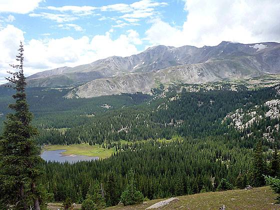
View of Native Lake and Mt. Massive
A pretty lake along with terrific views of the Continental Divide and Mt. Massive are a few of the scenic delights along this beautiful trail paralleling the eastern flanks of the Continental Divide west of Leadville.
See Trail Detail/Full Description
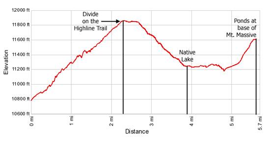
- Distance: 4.6 miles (round trip) to Divide between Busk and Rock Creek Drainages
7.8 miles (round trip) to Native Lake
11.2 miles (round trip) to Turnaround Point on the Highline - Elevation: 10,780-ft. at Trailhead
11,860-ft. at Divide between Busk and Rock Creek Drainages
11,240-ft. at Native Lake
11,615-ft. at Turnaround Point on the Highline - Elevation Gain: 1,080-ft. to Divide between Busk and Rock Creek Drainages
-620-ft. to Native Lake
375-ft. to Turnaround Point on the Highline - Difficulty: moderate-strenuous
- More Hikes in:
Leadville / Central Colorado
Why Hike Native Lake Highline Trail
The Native Lake / Highline trail traverses the eastern flank of the Continental Divide near Leadville. Along the way the route crosses a broad tundra clad plateau featuring wonderful views of the Continental Divide and Mt. Massive (14,421-ft.), visits scenic Native Lake and then wanders through woods and meadows to two small lakes along the base of Mt. Massive.
Elevation Profile
| Buy the BookThis opinionated guide includes all the hikes in the Aspen, Buena Vista, Crested Butte, Marble and Leadville sections of the website plus info on local services and nearby attractions. |
Trail Resources
Trail Detail/Full Description / Trail Photo Gallery / Trail Map
Basecamp(s) Information:
Leadville
Region Information:
Central Colorado
Other Hiking Regions in:
Colorado