Cirque at the head of Alp Trupchun
Val Trupchun is one of the best wildlife viewing areas in the Swiss National Park, offering hikers the chance to observe red deer, ibex, chamois, and marmots in a pretty valley to the east of S-chanf
- Distance: 5.6 - 11.6 miles (RT)
- Elevation: 5,810-ft. at Trailhead
Maximum elevation - 6,735-ft. - Elevation Gain: 925-ft.
- Difficulty: easy-moderate
- Basecamp: St Moritz
- Region: Eastern Switzerland
Trail Description - Alp Trupchun
The Swiss National Park is the largest nature and wilderness reserve in Switzerland. Val Trupchun, situated east of S-chanf, is one of the best wildlife viewing areas in the Park, offering sightings of red deer, ibex, chamois, and marmots. During the summer the valley is home to over 500 red deer. September, the rutting season, is an especially popular time for hikers to visit the area.
Hikers can easily explore Val Trupchun on a trail that ascends the north side of the valley, meandering through meadows and forests alongside the Ova da Trupchun, the valley’s river. Alternatively, a high trail on the valley’s south side offers a different perspective, rising about 300 feet above the valley floor before winding through forests and across some landslides. Both trails converge shortly before reaching Alp Trupchun, where the valley opens into beautiful meadows set beneath the scenic cirque ringing the head of the valley.
Designated rest areas around Alp Trupchun provide front row seat with views of surrounding hillsides where deer and other wildlife can be observed. Be sure to bring binoculars or a good zoom lens for your camera. Keep in mind that typically early morning and late afternoon are the best times for seeing wildlife.
Beyond the alp, a very steep route ascending to Fuorcla Trupchun (Trupchun Pass) offers opportunities to observe ibex and chamois. This is difficult route, climbing through steep scree fields, should only be tackled by experienced, sure-footed hikers. Before hiking to the pass, check out current conditions at the Parkhutte Varusch.
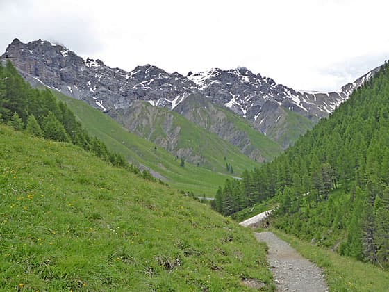
Trail to Alp Truchun

From St. Moritz, take the train to S-chanf Staziun, a trip that takes 23 to 28 minutes. From S-chanf there are four ways to start the hike to Alp Trupchun:
- 1)Take the Express Parc Naziunel or Alpin train, a shuttle bus that looks like a small train, from the S-chanf train station to Parkhutte Varusch. This is the easiest option. Note that this service typically runs from late June to early October.
- 2) Take the Engadin bus 7 (operating from early June to mid-October) to the stop at the Parasuras parking lot. From the lot it is a 1.5-mile hike to the Parkhutte. Parasuras is also a stop on the Alpin shuttle bus.
- 3)Drive to the Prasuras lot. From the lot it is a 1.5-mile hike to the Parkhutte. Parasuras is also a stop on the Alpin shuttle bus.
- 4> Hike from the S-chanf train station to the Varusch Parkhutte, a 3.0-mile walk.
For more information on all these options see the Directions to the Trailhead.
Hiking Distance to Alp Trupchun- Parkhutte Varusch to Alp Trupchun: 5.6 miles RT, Elevation Gain: 925-ft.
- Parasuras Parking Lot to Alp Trupshun: 8.6 miles RT, Elevation Gain: 1,200-ft
- S-chanf to Alp Trupchun: 11.6 miles RT, Elevation Gain: 1,400-ft.
Note: Two trails ascend to Alp Trupchun. The lower trail is the easier and less forested, traveling along the valley floor beside the river with nice views of the river and surrounding peaks. This is the more popular option and the best choice if the weather is not good.
The upper trail can be accessed from the Prasüras parking lot (behind the restaurant) or Punt da Scrigns, the shuttle bus stop, 0.25 miles before Parkhutte Varusch. Both access trails climb the south side of the valley and connect with the upper trail, an undulating path through forest that stays about 300-ft. above the valley floor. Along the way you will cross some landslides, which can be slippery when wet or snow covered. The upper trail is more forested, but openings offer more far-reaching views of the surrounding area.
The two paths meet a short distance before Alp Trupchun to form a loop. If hiking the loop, many hikers prefer to hike out the upper trail and return via the lower trail. This description covers the lower trail

Parkhutte Varusch, a hut managed by the Swiss National Park, offers accommodations, a small café and bathrooms. The hut is located at the last stop on the Alpin train shuttle bus. From here, a good trail heads east toward Alp Trupchun. The path ascends on easy to moderate grades through a diverse landscape of meadows and forest composed of larch, firs and pine trees along the left (north) side the Ova da Trupchun, the valley’s river. Constructed steps and bridges along the path facilitate the hike. Keep an eye out for marmots, deer and other wildlife along the way.
As the path gains elevation, turn around (west) for nice views of the ridge towering above Zuoz and S-chanf. At 0.5 miles the trail crosses Val Channels, a side valley branching north. Soon views open to Piz Fier and Piz Saliente, punctuating the ridge at the head of the valley, along with a few summits rimming the valley to the north.
The trail passes a minor drainage and then crosses a good bridge to the south side of the river at 1.0 mile. Reach a junction at Alp Purcher a short distance beyond. Here a trail climbs the hillside to the upper trail. We continue traveling up the valley on the lower trail beside the river.
At 1.25 miles the path passes Val Muschauns, a large side valley branching north, and then crosses a bridge back to the north side of the valley to a trail junction at 1.25 miles. Here routes, marked with blue signs, head up Val Muschauns. We stay on the main trail that climbs steeply up switchbacks through the trees. The steep climb, aided by steps, soon ends and the path now continues ascending on gentler grades.
A short distance beyond, the trees give way to meadows and great views open to the head of the valley. In early July the meadows are sprinkled with beautiful wildflowers. As the path continues up the valley it crosses a few more minor drainages.
At 2.3 miles reach a junction where the upper and lower trails meet. Below the junction a bridge spans the river allowing hikers on the upper trail to cross to the north side of the valley and then ascend a short distance to join the lower trail, which continues up the valley. Ahead are gorgeous views of the peaks towering above the head of the valley. The obvious saddle on the ridge is Fuorcla Trupchun (Trupchun Pass).

Shortly after the junction the trail passes the first official rest area, where you can sit, picnic and enjoy the views both up and down valley. Since you are in the National Park you must stay within these designated rest areas when picnicking or resting off the trail. The rest area is a good place to look for wild animals, such as deer and ibexes, on the surrounding hillsides. Be sure to bring binoculars and/or a camera with a zoom lens to better spot and photograph the wildlife.
Beyond the picnic area the trail traverses a wide, rocky drainage at the base of Val Mela, another north branching side valley. Rock cairns mark the route across the rocky drainage.
Past Val Mela the trail continues up the valley, crossing one more drainage before reaching Alp Trupchun (6,693-ft. / 2,040-m) at 2.6 miles. The private hut at the Alp does not serve food or drink and will likely be closed. Near the Alp is a second designated rest area where you can sit, picnic, enjoy the views and look for wildlife.
Beyond this point a path heads up the valley toward the route climbing to Fuorcla Trupchun. We continued a short distance past the hut before turning around at 2.8 miles and retracing our steps back to the trailhead. Alternatively, you can take the upper trail back for some variety by crossing to the bridge to the south side of the river past the first rest area.
After climbing to the upper trail, signs will direct you back to Punt da Val da Scrigns, where hikers can descend to the road and a stop for the Alpin bus. Another option is to walk 0.25 miles up the road from Scrigns to the Parkhutte for refreshment. Alternatively, stay on the high route to the Prasüras car park or walk back to S-chanf.
Elevation Profile

Driving Directions
From St. Moritz, take the train to S-chanf Staziun, a trip that takes 23 to 28 minutes. There are four ways to start the hike to Alp Trupchun.
- 1) The Express Parc Naziunel or Alpin train, a small shuttle bus that looks like a train, takes hikers from the Zuoz or S-chanf train stations to Parkhutte Varusch. The service typically runs from late June to early October. On the SBB timetable, the Express Parc Naziunel is designated as «T19» or T 619. See the Alpin Bus website: https://alpintrans.ch/ for current scehdules and prices.
- 2) Engadin bus number 7, which does not stop at the S-chanf train station but at the Chesa Cumunela in S-chanf, goes to the S-chanf, Parc Naziunal stop at the Prasüras car park. When looking for bus times use S-chanf, Parc Naziunal on the SBB timetable, not Prasüras car park. If walking from the car park to the Parkhutte, you have the choice of either following a gravel track/road or a forest path. The road is better as the views are more open and it is faster. Walking time from Prasüras is 35 - 45 minutes and 1.5 miles on the gravel track.
- 3) Private vehicle: Drive from S-chanf to the free Prasüras car park (entrance to Val Trupchun). From there, driving is prohibited. From the parking area you can take the Express Parc Naziunel or Aplin train to Parkhutte Varusch. If walking from the car park to the Parkhutte, you have the choice of either following a gravel track/road or a forest path. The road has better views and it is faster. Walking time is 35 minutes to 45 minutes and 1.5 miles on the gravel track.
- 4) The last option is to follow the hiking signs from S-chanf train station to the Varusch Parkhutte, a 3.0-mile hike. The hike follows the road leading out of S-chanf, crosses the River Inn on a bridge, crosses under the highway using an underpass and then travels along the park road to Parkhutte Varusch. After crossing under the highway there are also signed trails that ascend through heavy forest to the Parkhutte. The road is the fastest option.
For bus, train and shuttle information to S-chanf and Parkhutte Varusch visit the SBB website or download the SBB app to find the routes, schedules and stop nearest your accommodations. Note that Parkhutte Varusch is listed as “S-chanf, Varusch” on the SBB schedules. The parking lot at Prasuras is “S-chanf, Parc Naziunal” on the SBB schedule. See the Alpin Bus website: https://alpintrans.ch/ for current schedules and prices.
Trail Resources
- Trail Photo Gallery
- Trail Maps
- Basecamp(s) Information: St Moritz
- Region Information: Eastern Switzerland
- Other Hiking Regions in: Switzerland